The Kineret and the Yarden

 Ahuva has a work thing on Friday so we decided to do a Thursday hike. It's a very light week of work for Gershon and me so we were easily able to take off and Shira and Ahuva were able to get the day off too. In mapping out the hike, we couldn't find a good place to end. We're pretty comfortable walking about twenty kilometers each time but there was nothing that looked convenient. We figured that we'd play it by ear a little. We put in something called Chaim B'Teva to WAZE hoping we'd be able to park there. That would be about 16 kilometers but was the best we could do without going to far from the shvil. We met at about 6 but were afraid to drive it in the dark. The "road" was very rocky and we weren't sure our cars would be ok. So we decided to park at a school near the path. It was about 2 kilometers off the shvil. So our hike would be 18 even though we'd only be doing 16 on the shvil. 

We drove back to Yaar Shveitz together to start our hike. The forest is very pretty with beautiful views of the Kineret. We started walking a few minutes before 7. Overall, the walk was very easy and mostly on wide paths. We've noticed though that there are fewer markers when you're walking on those kinds of paths. We got lost a couple times. Actually, lost is the wrong word. With all the maps we have on the phones, it's hard to get lost (though I'm sure it's not impossible) but we went off the path. In total we probably walked about two kilometers off the path until we got back going the right way. It wasn't awful but was the worst we've done with it. 

We continued our trek south which is the direction we've been walking almost all the time. We got to the bottom of the Kineret and then walked along the Yarden for a little while. The picture is at Rob Roy which is a canoeing place we'd been to a couple times right at the top of the Yarden. Then we turned right to start heading west. The next few hikes will be mostly west until we get near the coast. 

Gershon said that this was his favorite hike so far. It was very pretty and the weather was perfect though it was quite muddy in some places. As mentioned, it was easy most of the time until the last couple kilometers on the shvil. We climbed a mountain and then walked through some relatively rough terrain. We saw some ducks along the way and lots of cows though we didn't get too close to any of them. Last time, I pet a cow but this time I didn't have that opportunity. In the end, we walked a little more than 20 km and it took us less than six hours. 


Mount Arbel

 One of the challenges of planning the monthly hikes is figuring out where we should end. It would be great if we could just start walking and end at a certain time or when we feel like we've had enough but because we park one car at the end point, we need to decide that before we leave. Sometimes we cover as little as two kilometers in an hour and others as much as five so it's very hard to estimate. We seem to average about 3 km per hour which seems very slow but, including our very short stops and time we spend doubling back because we missed a turn or whatever, that seems to be our average. Given the short Friday and the still relatively long drives, we decided that about 15 km was the right amount for this hike. In the end we found a place to park 16 kilometers after our starting point and figured that was perfect. 

We met at our ending in the middle of the Schweitz (Swiss) Forest which had some sentimental value to Ahuva since some of her family comes from Switzerland. We got there around 5:15 and then drove together to our starting point in Migdal. We davened and were on our way by 6:10. That was about twenty minutes before sunrise but by that hour it's light enough that you can start hiking. This was especially true this time because the beginning was walking through the city of Migdal where it was very well lit. 

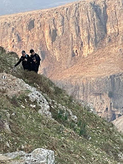
After a kilometer or two, we got to the base of Mount Arbel. We don't do any advance scouting and really never know what we're going to hit on the hikes so it's always a surprise to us. First there were steep steps going up. It was tiring but not difficult and we were doing great. That only got us halfway up the mountain though. Then it was more difficult climbing. There were some bars to grab but a lot of the time it was just holding onto rocks. For people with a fear of heights this proved to be scary but we all did great and got to the top of the mountain. I don't clock every section so I don't know our exact speed but I'd guess we went no more than 2 km per hour up the mountain (including stopping to wait for stragglers or to rest). 

By that point, I was starting to get a little nervous about time. We had a 30 minute drive back to our cars and then a 2+ hour drive home. Candle lighting was 4:16. We were each having company and had stuff to do to prepare for Shabbat. Luckily, there was no steep decline to get down Arbel and we made excellent timing. We walked on the edge of Kfar Hittim and Mitzpe before walking for a while in the city of Teverya Ilit. Then we got to the Swiss Forest and walked the last 3 km or so on walking/biking roads in there. 

Besides the climb up the mountain, the walk was very easy overall and we made great timing. We covered 16 kilometers in about 5 hours. We were home before 2. I really enjoyed this hike and if I were to rank the hikes we've done so far this would probably be number 1. The views of the Kineret were really nice and the temperature was perfect.